~Thunacar Knott & Friends~
22nd October 2016
A tour of The Langdale Pikes and some near neighbours.

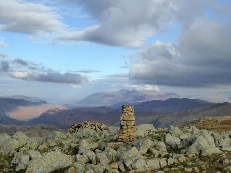
Bowfell from Thunacar Knott
Scroll down for photos and a description of the walk....
 |
 |
The National Trust car park at "Sticklebarn" is not too crowded at 07:45hrs. Molly and me set off up Stickle Ghyll for Stickle Tarn; sunrise is happening behind us as we climb.

Stickle Ghyll
The low sunlight livens up the Autumn colours on this, this is a "first class" ascent, one of the best in Lakeland. The next 45 minutes or so, a bit longer for those who sit down too often, is fantastic.

~~~

~~~

Misty Morning
The rising sun's rays illuminate Autumn mists from Elterwater and across the fields of Chapel Stile.

We turn the corner and enter the final stretch up to the tarn. On colder days, I hope for ice and today I am hoping for still waters as there is no breeze at this time.

Stickle Tarn
Perfectly still water and a view of Pavey Ark with a mirror image on the water. Today I join the ranks of the "eccentric", the people who "set forth with the sole object of scaling this particular fell (Thunacar Knott) and no others en route.." Well, it's not my sole objective but I have a determination to climb all the "Wainrights" without the use of adjoining ridges and so this day had to come. But it's not easy to get to the summit of Thunacar Knott without, even accidentally, hitting the top of a neighbouring fell on the way.

The chosen route was to aim between Harrison Stickle and Pavey Ark, as per the red dots. Not safe in mist - you are likely to ascend to the top of Pavey Ark and not find Thunacar Knott.

Thunacar Knott
Well here it is, a "completely unphotogenic" fell. It remains a mystery as to why this landscape has a name and even more so, what is/was "Thunacar"? Possibly the Norse God of the Unintended? If this was a game of "Top Trumps" the only possible criteria upon which you could win a duel would be on height; nothing else here has any merit.
 |
 |
Thunacar Knott Summit 2,351ft asl |
View to High Raise |
It's possible I have misjudged this area. In my five visits, I have yet to meet anyone and each time I have noticed how quiet it is up here - in our modern lives, silence is so hard to come by, but just here there is no sound but that of the movement of grass in the wind and the occasional passing aircraft.

Bowfell from Thunacar Knott

High Raise Summit 2,500ft asl
A mile of easy walking and we are at High Raise summit. Time for a break in the well-made shelter that you'll find up here. Clouds are drifting in from the east and late starters will regret their tardiness as brightness and colour decline.

High Raise Tarn
Not one for the picnic rug, but a point of navigation on the route to Sergeant Man. We have just passed another walker for the first time today (10:15hrs) and he can be seen on the horizon close to the top of High Raise.
 |
 |
Sergeant Man Summit 2,414ft asl |
Bright Beck |
Sergeant Man summit acts only as a point on the map, nothing to get excited about here. There are some fine ascent routes of Sergeant Man from Grasmere. We will head down to the foot of Bright Beck and head up Pavey Ark via the North Rake.

The North Rake of Pavey Ark

Pavey Ark Summit 2,288ft asl
Walkers are now evident in a kind of profusion consistent with a sponsored event, but there are no printed t-shirts. Jack's Rake climbers all appear with smiles on their faces. Medals have been awarded for less.
 |
 |
To Harrison Stickle |
Stickle Tarn |
It's a well-worn track from Pavey Ark to Harrison Stickle, we are now within the Langdale Pikes and I met a family from Oldham who had left home at 07:30hrs, roughly the same time as I switched off the engine. Nothing wrong with any of that, but I do like the empty roads and choice of car park spaces.

Harrison Stickle is the most prominent of the "Pikes" when you drive in from Chapel Stile. At 2,403ft asl, it is the highest of the peaks in this area. We endured a few minutes at the top with many others and all manner of contorted "selfies" being taken with long arms and resultant odd facial expresions. We are heading for Pike O'Stickle, half a mile away.

Pike O'Stickle

Pike O'Stickle Summit 2,323ft asl
Loft Crag is over there to the right and the obvious choice for our next stop.
 |
 |
However, I wanted to see if Thunacar Knott could be a more popular place in the afternoon and we crossed the hinterland (left) to find absolutely nobody, but a fractured rock caught my eye.

Descent to Stickle Tarn
Time to head back down to Stickle Tarn, much the same way as we came up earlier in the day.

~~~

~~~

The Car Park
Walkers: Molly and Me.
Time taken: 7hrs over a distance of about 10 miles.
Route: Sticklebarn Car Park, Stickle Ghyll, Stickle Tarn, Thunacar Knott, High Raise, Sergeant Man, Bright Beck, North Rake to Pavey Ark, Harrison Stickle, Pike O'Stickle, Thunacar Knott, Stickle Tarn, Stickle Ghyll.
Weather and conditions: Sunny start, declining to overcast with light drizzle. Steadily improving later on to sunny spells (just after we completed the walk).
All photos copyright Richard Ratcliffe 2016 ©
Take me back to the start ....